| Ref |
Subject |
Description |
Size |
Price |
Image |
| Mx0281 | Warwickshire | Creighton, R and Walker, J & C. Birmingham town plan, published in Samuel Lewis's Topographical Dictionary of England, 1835. The plans were originally produced to illustrate the boundaries of boroughs in relation to the great Reform Act of 1832. Steel engravingwith original hand colouring. | h 183mm x w 236mm | £15 | 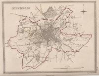 |
| Mx0280 | Warwickshire | Creighton, R and Walker, J & C. Warwick and Coventry town plans,published in Samuel Lewis's Topographical Dictionary of England, 1835. The plans were originally produced to illustrate the boundaries of boroughs in relation to the great Reform Act of 1832. Steel engravingwith original hand colouring. | h 183mm x w 267mm | £12 | 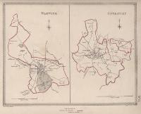 |
| M0276 | Warwickshire | Walpoole, G A, c1784. A New Map of Warwick Shire drawn from the latest authroities. Originally published in The New British Traveller issued weekly by Alexander Hogg, from 1783. In 1784 it was issued as a single volume. The maps vary in size and have adjoining borders, with up to a page. Therefore individual maps will be trimmed to the border on one or two sides. Copper engraving. | h 178mm x w 110mm | £18 | 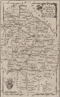 |
