| Ref |
Subject |
Description |
Size |
Price |
Image |
| MX0480 | Scotland | Ports and Harbours on the North east Coast of Scotland: Burghead, Nairn, Fraserburgh, Lossiemouth, Banff and Macduff, c1866. Engraved by G H Swanston from Admiralty Surveys, published by Fullarton & Co. Engraving. | h 228mm x w 127mm | £20 |  |
| M0231 | Scotland | Bowen, Eman, 1747 A New and Accurate Map of Scotland. Compiled from Surveys, and the most approved Maps and Charts, The whole being adjusted by Aston, l. Observation. From A Complete System of Geography. Hand coloured. Small repaired tear bottom left. | h 317mm x w 222mm | | 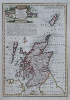 |
| M0083 | Scotland | Gerard Mercator, Scotia Regnum, 1607 or later, hand coloured engraved map of the whole of Scotland with distinctive strapwork title cartouche, staining, French text to verso
| h 347mm x w 403mm | £420 | 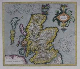 |


