| Ref |
Subject |
Description |
Size |
Price |
Image |
| M0075 | Oxfordshire | Christopher Saxton, & William Hole, 1607-1637 hand coloured. This edition has no text on the reverse of map. | h 270mm x w 290mm | £230 | 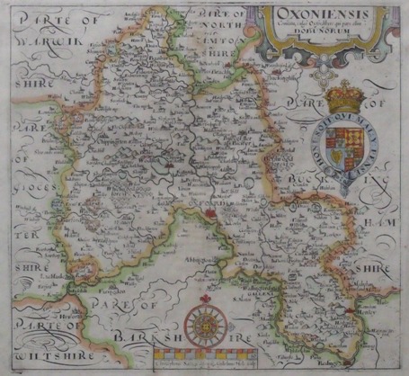 |
| 37 | Oxfordshire | Owen - Bowen, A Map of Oxfordshire, c1730. Hand coloured. Mounted | 185x115mm | £38 |  |
| 36 | Oxfordshire | T Kitchen, Oxfordshire drawn from a survey and regulated by Astronomical Observations, c1747. hand coloured, mounted. | 205x170mm | £46 |  |
| 35 | Oxfordshire | Richard Blome, A Mapp of Oxfordshir with its Hundreds. hand coloured, mounted. | 182x215mm | £80 |  |
| 34 | Oxfordshire | George A Walpoole, A New Map of Oxfordshire drawn from the latest and best Authorities, c1784, hand coloured, mounted. | 198x155mm | £35 |  |
| 33 | Oxfordshire | Thomas Moule, Oxfordshire, c1842. hand coloured with good margins. Mounted | 255x190mm | £70 |  |
| 32 | Oxfordshire | t Kitchen, A New Map of Oxfordshire drawn from the best Authorities, c1764, hand coloured, mounted. | 250x187mm | £55 |  |
| 31 | Oxfordshire | Moule, City and University of Oxford c1842, hand coloured with good margins. Mounted | 243x184mm | £70 |  |
