| M0386 | North America | Adrien Hubert Brue, c1825; Carte Generale des Etats-Unis Mexicains et des Provinces-Unies de l'Amerique Centrale. This map shows California, the Southwest, and Texas, which is named still as part of Mexico. The western topography is based on the expeditions of Lewis and Clark, Pike and Long. It is the first map to show the Sacramento and San Joaquin Rivers. Other rivers on the West Coast hint at a possible navigable connection between the Atlantic and Pacific. There is an inset titled Guatemala ou Provinces-Unis de l'Amerique Centrale. The author's copyright is blind stamped into the paper at the bottom of the inset. Outline colour. This map is mounted, framed and glazed. | h 505mm x w 360mm | £180 | 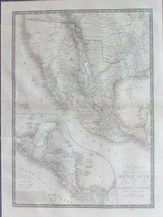 |

