| Ref |
Subject |
Description |
Size |
Price |
Image |
| Mx0348 | Herefordshire | John Cary; Herefordshire c1783. Copper engraving with early outline colouring.
| h 264mm x w 210mm | £45 | 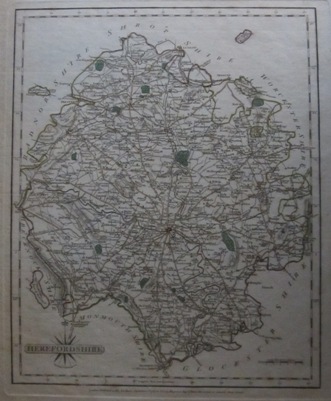 |
| Mx0275 | Herefordshire | Blome, Richard. c1673 A generall Mapp of Hereford with its hundreds by Ric Blome by his Majestys Especial command. Copper engraving. | h 305mm x w 285mm | £120 | 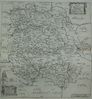 |
| Mx0274 | Herefordshire | Morden, Robert. c1695 Hereford shire. | h 360mm x w 420mm | £80 | 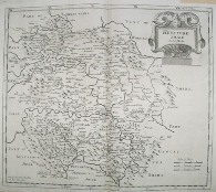 |
| Mx0273 | Herefordshire | Moll, H. c1724 Hereford shire. | h 190mm x w 312mm | £68 | 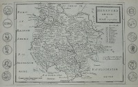 |
| Mx0272 | Herefordshire | Cary, John. 1809 Herefordshire. Original hand colouring. | h 262mm x w 210mm | £30 | 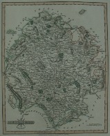 |
| Mx0271 | Herefordshire | Kitchen, Thomas, c1765; A New Map of Hereford Shire Drawn from the best authorities, by Tho Kitchin Geogr., Engraver to H.R.H. the Duke of York. | h 256mm x w 195mm | £35 | 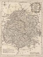 |
| Mx0262 | Herefordshire | Osborne, Thomas c1748 A Correct Map of Hereford Shire, from Geographia Magnae Britanniae. Copper engraving | h 145mm x w 172mm | £38 | 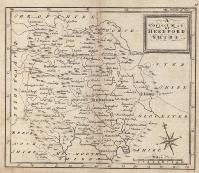 |
| Mx0261 | Herefordshire | Seller / Grosse. Herefordshire. c1773 Original hand colour. | h 123mm x w 147mm | £28 | 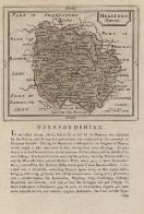 |
| Mx0260 | Herefordshire | Moule, T c1836. This map appeared in several editions. This would appear to be an earlier edition as it does not include any railways. Moule's maps are considered to be the last decorative county maps to be issued. Includes vginettes of the Goodrich Castle, Carnstone House and Heereford cathedral.
Good margins. | h 267mm x w 183mm | £40 | 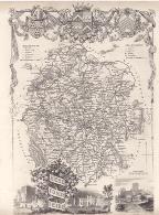 |
| Mx0257 | Herefordshire | Wyld, J: c1830. Map of The River Wye and adjacent country from Monmouth to Ross. Showing sections of the River Wye from Monmouth to Ross. Published by Wrightson & Webb, Birmingham. | h 190mm x w 105mm | £18 |  |
| Mx0256 | Herefordshire | Badeslade, T & Toms, W H, c1742. This small map of the county is from "Chorographia Britanniae" The panel on the left of the map shows a list of towns in the county with details of their market and fair days. Imprint beneath the map dated Sept. 29, 1741 | h 143mm x w 145mm | £32 | 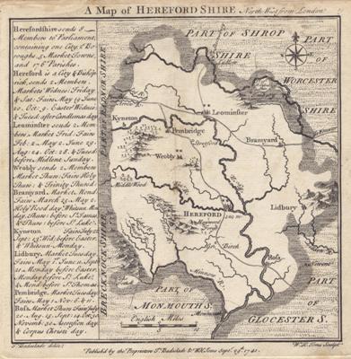 |
| Mx0254 | Herefordshire | Archer, J. c1845 Herefordshire. Steel engraving. Horizontal centre fold as issued. Hand coloured. | h 223mm x w 164mm | £8 | 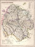 |
| Mx0253 | Herefordshire | Kitchin, 1747 - 1786, Herefordshire drawn from the Best authorities. Hand coloured. | h 170mm x w213mm | £48 | 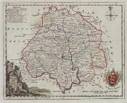 |
| Mx0252 | Herefordshire | Ramble, Reuben,1845,Herefordshire. Issued in Travells through the counties of England. Vignettes with orignal hand coloring. Scarce | h 175mm x w 148mm | £65 | 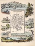 |
| M0304 | Herefordshire | Thomas Conder, c1784. A New Map of Hereford Shire drawn from the latest authorities. Published by Alex Hogg. This map was issued with another adjoining it so is trimmed to the left hand margin. Copper engraving. | h 198mm x w 160mm | £35 |  |
| M0270 | Herefordshire | Wallis, J. c1810; Herefordshire. Original hand colouring | h 134mm x w 95mm | £12 | 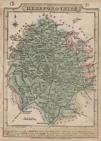 |
| M0258 | Herefordshire | Ellis,John c1777 A Modern Map of Herefordshire, Drawn from the latest Surveys; Corrected & Improved by the best Authorities. W Palmer Sculp. Imprint of Carington Bowles in St. Pauls Church Yard and Robert Sayer in Fleet Street.
| h 250mm x w 193mm | £25 | 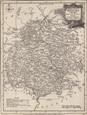 |
| M0114 | Herefordshire | Ogilby, John, c1698 Hereford to Leicester. The route goes through Worcester, Droitwich, Bromsgrove, Allchurch, Solihull, Meriden, Coventry Woolvey and Sharnford. | h 380mm x w 507mm | £120 | 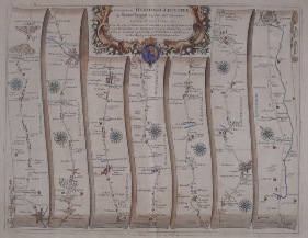 |


