| Ref |
Subject |
Description |
Size |
Price |
Image |
| Mx0373 | The World | John Emslie; Rivers and Lakes, c1860. Geographical diagram showing the comparative sizes and shapes of many of the world's lakes and rivers. The 41 rivers, include the Thames, Danube, Rhine, Nile, and Amazon. The 36 'lakes' include the Dead Sea, the Caspian Sea, Lake Geneva and Lake Superior.This is from a series of 44 scientific teaching diagrams, on geology, geography, astronomy and natural philosophy published by James Reynolds. Original hand-colouring. | h 265mm x w 195mm | £35 | 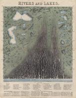 |
| M0388 | The World | Brue, 1820. Mappe Monde en Deux Hemispheres. Originally published in the Atlas Universel. Early outline colour. Mounted, Framed and glazed. | h 290mm x w 550mm (image) | £120 | 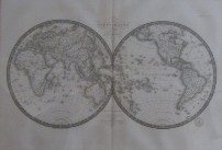 |
| M0387 | The World | Rigobert Bonne,Primario Hydrographo Navali c1780. Orbis Antiquus. This detailed map of the Eastern Hemisphere: Europe, Africa, Asia was published in the Atlas Encyclopedique. Engraved by Gaspar Andre. Copper engraving. Mounted, framed and glazed. | h 240mm xw 345mm (printed area | £65 | 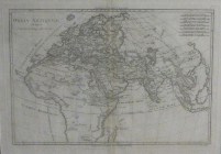 |
| M0212 | The World | Tallis, John; c1851, Western Hempishere. Original outline colour, central fold. | h 260mm x w 345mm | £225 | 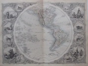 |


