| Ref |
Subject |
Description |
Size |
Price |
Image |
| M0235 | Surrey | Speed,John;Surrey descibed and divided into hundreds, Published by George Humble c1627. Hand coloured. Repair to top left-hand corner. | h 380mm x w 507mm | £950 | 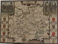 |
| 52 | Surrey | The County of Surrey c1870, printed colour. This map shows the railway lines and parliamentary boundaries. Mounted | h 155mm x w 200mm | £15 |  |
| 51 | Surrey | Moule, Surrey c1842, hand coloured trimmed to margins on left. Mounted | 200x255mm | £70 | 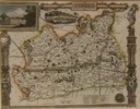 |
| 38 | Surrey | Moule, Surrey c1842, hand coloured with good margins. Mounted | 200x265mm | £90 |  |
| 29 | Surrey | Owen - Bowen, A Map of Surrey, c1730 with road map of Chiddingfold to Petersfield on reverse. Hand coloured. Mounted | 180 x113mm | £ 48 |  |
| 28 | Surrey | C19th cent. Hand coloured engraved map. Mounted | 110 x 150mm | £20 |  |
| 27 | Surrey | publ. R Miller, c1821 from the New Miniaturwe Atlas, hand coloured and mounted | 73x106mm | £32 |  |
| 19 | Surrey | J Stockdale, J A Map of Surrey 1798 | | £45 |  |
| 18 | Surrey | C Smith; A New Map of the County of Surrey, double-page hand-coloured engraved map, repaired at fold on verso, 450 x 510mm., 1801 | | £120 |  |
| 17 | Surrey | Charles and John GREENWOOD, Map of the County of Surrey, double-page hand-coloured map engraved by J. & C. Walker, inset view of Lambeth Palace and Church, light offsetting, Greenwood, 1829 [but c.1834, | 565mm x 680mm | £150 |  |
| 1 | Surrey | Johannes Bleau, 1645-1648, hand-coloured map with decorative cartouche and bordered by coats of arms. Framed | | £440 |  |

