| Ref |
Subject |
Description |
Size |
Price |
Image |
| Mx0418 | Staffordshire | Eman Bowen,. Staffordshire Divided into its Hundreds: Containing the Boroughs & Market Towns Ancient Roads etc. Copper engraving. Engraved for the "General Magazine of Arts & Science for W Owen at Temple Bar 1760". Two horizontal folds as issued. | h 185mm x w 167 | £45 |  |
| Mx0375 | Staffordshire | Christopher Saxton and William Kip c1610 Staffordiae comitatus pars olim Cornauiorum. This was the second edition of this map to be published. It differs from the first edition in that it has no text on the reverse. | h 268mm x w 374mm | £220 | 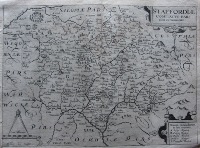 |
| Mx0371 | Staffordshire | R Creighton and J & C Walker; Staffordshire c1831-1848. Engraved for Lewis' Topographical Dictionary. With early hand colouring. | h 234mm x w 177mm | £18 | 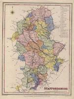 |
| Mx0366 | Staffordshire | R Creighton and J & C Walker; Staffordshire c1831-1848. Engraved for Lewis' Topographical Dictionary. | h 234mm x w 177mm | £16 | 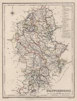 |
| MX0458 | Staffordshire | Staffordshire, 1808. Drawn by G Cole and engraved by J Roper. Published by Vernor, Hood & Sharpe in "The British Atlas" which accompanied the "Beauties of England & Wales". Copper engraving with later hand colouring. | h 234mm x w 175mm | £35 |  |
| MX0440 | Staffordshire | Staffordshire, by Francis Grosse, c1790. Copper engraving with original/early hand colouring. Text continues on the reverse. | h 225mm x w 145mm | £15 |  |
| MX0434 | Staffordshire | Staffordshire, by Francis Grosse, c1790. Copper engraving. Text continues on the reverse. | h 225mm x w 145mm | £15 |  |
| M0365 | Staffordshire | J Roper and G Cole; Staffordshire,c1808 copper engraving with later hand colouring. | h 230mm x w 175mm | £32 | 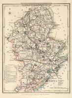 |
| 56 | Staffordshire | J Rocque, Stafford Shire, c1753. Hand coloured. Mounted | h 200mm x w 170mm | £28 | 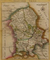 |
| 55 | Staffordshire | T Conder, A New Map of Staffordshire, c1786. Hand coloured , Mounted | h 122mm x w 145mm | £32 | 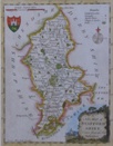 |
| 54 | Staffordshire | Moule, Staffordshire, c1842, hand coloured good margins. Mounted | h 260mm x w 190mm | £47.50 | 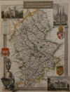 |


