| Ref |
Subject |
Description |
Size |
Price |
Image |
| MX0454 | Russia | Russia, c1850. Engraved by F P Parker & Co. Published by Virtue & Co. Steel engraving with original outline hand colour. | h 342mm x w 197mm | £15 |  |
| M0389 | Russia | John Speed; A Newe Mape of Tartary by Roger Rea, c1662. This is the rare edition by Roger Rea. This map covers the Caspian Sea in the south west to Moskua Moscow) and extends southwards to Tagalistan and western China where the Great Wall is clearly marked. Korea is shown as an island. Part of America is shown separated by the Strait of Anian. There are eight figures in native costume in the side panels. The upper border contains views of four cities; Astracan, Samarchand, Cambalu (Alma-Ata) and 'the' house on Nova Zemla. This map is in a double window mount to reveal the english text on the reverse. Copper engraving with later hand colouring. | h 390mm x w 500mm | £1500 | 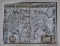 |
| M0144 | Russia | Southern part of Russia in Europe c1799, Engraved for Walker's Geography. Part early outline colour | h 185mm x w 215mm | £15 | 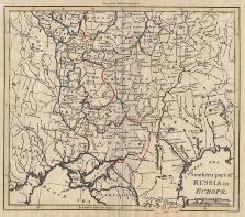 |
| M0143 | Russia | Russia or Moscovy in Europe c1760 | h 180mm x w 225mm | £28 | 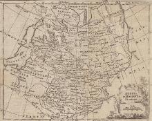 |
| M0142 | Russia | Cowley, John; c1777. Russia or Muscovy in Europe. Engraved map with later hand colouring.Loss to lower margin just touching border but not effecting image. | h 135mm x w 108mm | £35 | 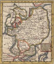 |


