| Ref |
Subject |
Description |
Size |
Price |
Image |
| MX0397 | London | Baynards Castle Ward and Farringdon Ward within with their Divisions into Parishes according to a new Survey, 1755. Engraved by B Cole and published in William Maitland's 'History of London from its Foundation to the Present Time'. Copper engraving with later hand colouring. There are Views of St Bennet's Church, St Martin's Church and St Andrew's church. Maitland's ward plans were largely derived from Strype's plans, with the illustrations copied from West & Tow's 1736 'Prospect Views of Ancient Churches'. | h 360mm x w 462mm | £75 | 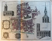 |
| M0411 | London | A New and Correct Plan of Limestreet Ward with its Division into Parishes according to a new Survey, 1755. Engraved by B Cole and published in William Maitland's 'History of London from its Foundation to the Present Time'. Copper engraving with later hand colouring. Includes a view of Leaden Hall. These ward plans were largely derived from Strype's plans. Tear on right hand border not affecting image. | h 233mm x w 358mm | £65 | 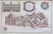 |
| M0410 | London | A New and Correct Plan of Limestreet Ward with its Division into Parishes according to a new Survey, 1755. Engraved by B Cole and published in William Maitland's 'History of London from its Foundation to the Present Time'. Copper engraving with later hand colouring. Includes a view of Leaden Hall. These ward plans were largely derived from Strype's plans. | h 233mm x w 358mm | £65 | 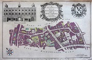 |
| M0408 | London | Aldersgate Ward with its Division into Precints and Parishes and the Liberty of St Martins le Grand according to a new Survey, 1754. Engraved by B Cole and published in William Maitland's 'History of London from its Foundation to the Present Time'. Copper engraving. Includes views of the Parish Churches of St Anne within Aldersgate and St Botolph Without Aldersgate. These ward plans were largely derived from Strype's plans. Minor thinning or paper with pin hole near bottom margin. Otherwise a fine copy. image. | h 238mm x w 375mm | £50 | 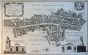 |
| M0407 | London | Aldgate Ward with its Division into Precints and Parishes according to a new Survey, 1755. Engraved by B Cole and published in William Maitland's 'History of London from its Foundation to the Present Time'. Copper engraving. Includes views of the Parish Churches of St James's and St Catherine,Coleman. These ward plans were largely derived from Strype's plans. | h 235mm x w 360mm | £60 | 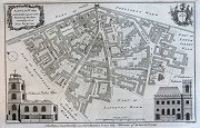 |
| M0406 | London | Aldgate Ward with its Division into Precints and Parishes according to a new Survey, 1755. Engraved by B Cole and published in William Maitland's 'History of London from its Foundation to the Present Time'. Copper engraving with later hand colouring. Includes views of the Parish Churches of St James's and St Catherine,Coleman. These ward plans were largely derived from Strype's plans. | h 235mm x w 360mm | £60 | 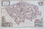 |
| M0398 | London | The Wards of Coleman Street and Bassishaw taken from the last Survey with corrections and amendments, 1754. Engraved by B Cole and published in William Maitland's 'History of London from its Foundation to the Present Time'. Copper engraving with later hand colouring. Includes views of two churches: St Stephen Coleman Street and St Michael Bassishaw. These ward plans were largely derived from Strype's plans, with the illustrations from West & Tow's 1736 'Prospect Views of Ancient Churches'. | h 365mm x w 247mm | £65 | 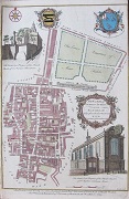 |
| M0395 | London | William Stukeley, November 1722. Londinium. Copper engraving. Map showing Roman London as known at the time. Slight age stating to paper, mainly affecting borders. Otherwise a good copy. | h 272mm x w 173mm | £45 | 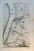 |
| M0393 | London | Map of the Route of the Queen's Diamond Jubilee Procession,1897. Published by Frederick Warned & Co. (Folding map with adverts on reverse. | h 320mm x w 481mm | £45 | 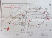 |
| M0079 | London | John Baptiste Homann, Haupt und Residenze Stadt London; c1740 Map of Middlesex with 5 large inset views of Royal Residences and buildings (Windsor Castle, Hampton Court, Chelsea and Greenwich Hospitals, Kensington Palace). Hand coloured | h 490mm x w 580mm | SOLD | 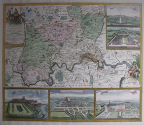 |


