| Ref |
Subject |
Description |
Size |
Price |
Image |
| MXA0019 | Africa | West Africa, 1820. Engraved by Kirkwoods and published by Waugh & Innes * Kirkwood & Son. Engraved map with outline hand colouring. | h 337mm x w 276mm | £35 | 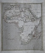 |
| MXA0016 | Africa | Plan of the Harbour and Adjacent Territories of Mosambique laid down partly by Geometrical Observatgions and partly collated from Original Portugese Charts by Henry Salt Esqr, 1809. Engraved by A Macpherson and published 30th May 1814 by F C & J Rivington. Copper engraving. Condition - central hprizontal fold. Age discolouration ot page. | h 335mm x w 237mm | £35 | 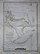 |
| MXA0010 | Africa | An Accurate Copy of D'Anville's Map of the Coast of Guinea between Sierra Leona and the Crossing of the Line. Engraved by T Bowen for J Harrison, February 1788. Copper engraving. Condition - vertical folds as issued. | h 2200mm x w 460mm | £80 | 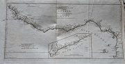 |
| MX490 | Africa | Africa, c1851. By John Tallis and J Rapkin. Steel engraving with original outline hand colouring. Condition - Stains to paper. Mainly along right-hand border. | h 248mm x 2328mm | £45 |  |
| MX0495 | Africa | A Map of the Kingdoms of Kongo, Angola, & Benguela with the adjacent Countries, from de l'Isle & others, by G Childe, 1746. Copper engraving. Condition - two vertical folds as issued. | h 242mm x w 305mm | £100 |  |
| MX0494 | Africa | Western Africa, c1882. Published by Blackie & Son, for "The Comprehensive Atlas & Geography of the World". Map by Edward Weller. Vertical centre fold as issued. Lithograph with outline colouring. | h 336mm x w 500mm | £35 |  |
| MX0493 | Africa | Natal and Kaffraria (Eastern South Africa) c1851. By John Tallis and J Rapkin. Steel engraving with original hand colouring. | h 357mm x w 247mm | £8 |  |
| MX0492 | Africa | Northern Africa, c1851. By John Tallis and J Rapkin. Steel engraving with original hand colouring | h 263mm x w 330mm | £70 |  |
| MX0491 | Africa | Western Africa, c1851. By John Tallis and J Rapkin. Steel engraving with original outline hand colouring. Condition - central fold as issued. | h 248mm x w 335mm | £45 | c1851. By John Tallis and J Rapkin. Steel engraving with original hand colouring |
| MX0486 | Africa | An Accurate Map of Barbary by Geo Rollos, Geogr, c 1773. Copper engraving. Condition - some discolouration mainly along borders. | h 194mm x w 285mm | £35 |  |
| MX0485 | Africa | A general map of the River Sanaga, from the falls of Govina to the Ocean: taken by a French Engineer in 1718, & drawn by Sr. d'Anville, from his particular draughts; Published by Labat and engraved by G Child. Copper engraving with later hand colouring. | h 237mm x w 382mm | £80 |  |
| MX0484 | Africa | Africa, c1872. Published by Blackie & Son, for "The Comprehensive Atlas & Geography of the World". Map by Edward Weller. This map has inset maps of Mauritius, Bourbon (Reunion) and Natal. Vertical centre fold as issued. Lithograph with outline colouring. | h 365mm x w 500mm | £65 |  |
| MA006 | Africa | Africa, North Part / Africa South Part, c 1850. Engraved by S Hall. Steel engraving with hand coloured outline. | h 380mm x w 265mm | £35 | 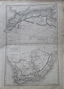 |
| MA0050 | Africa | Africa from the best Authorities, c1805. Copper engraving with hand colouring. Condition Age discolouration to paper. | h 187mm x w 217mm | £25 | 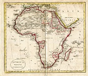 |
| MA0049 | Africa | Nigritia Guinea etc, 1 January 1822. Engraved by Neele & Son and published by Sherwood Neely & Jones. Engraving with original hand colouring. | h 186mm x 238mm | £22 | 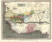 |
| MA0048 | Africa | A Plan of the Island and Fortifications of Goree on the Coast of Africa, 1759. Published by Richard Baldwin in the London Magazine. Copper engraving. | h 118mm x w 181mm | £35 | 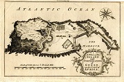 |
| MA0047 | Africa | Goree Bay, c1760. Published in the London Magazine. Copper engraving. Condition - surface loss to paper at bottom left-hand corner . | h 122mm x w 200mm | £15 | 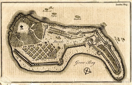 |
| MA0046 | Africa | Abbessinia and the Adjacent Countries, c1856. Published by A Fullarton & Co. This map of Ethiopia etc is from "A Gazetteer of the World or Dictionary of Geographical Knowledge". Steel engraving with original outline hand colouring. | h 152mm x w 227mm | £12 | 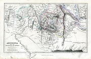 |
| MA0045 | Africa | A Map of the Countires bordering on the Rivers Sanaga & Gambia, 1759. Published in the London Magazine. Copper engraving. | h 182mm x w 186mm | £50 | 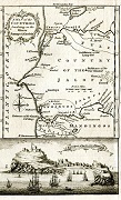 |
| MA0044 | Africa | Cape Verde Islands from the Admiralty Survey, c1856. Published by A Fullarton & Co. in "A Gazetteer of the World or Dictionary of Geographical Knowledge". Steel engraving with original outline hand colouring. | h 138mm x w 235mm | £12 | 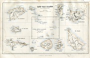 |
| MA0043 | Africa | Map of part of Central Africa according to Clapperton, Denham, Richardson, Barth, Vogel and Baikie from the original documents in possession of the Royal Geographical Society of London, 1859. This map of Lake Chad & its surroundings is from "A Gazetteer of the World or Dictionary of Geographical Knowledge" by A. Fullarton & Co. Steel engraving with original outline colour. | h 152nn x w 248mm | £12 | 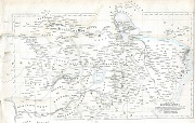 |
| MA0042 | Africa | Africa including the Mediterranean, circa Mid-19th Century. Engraving. Condition -m 2 vertical folds possibly ass issued. A small "worm" hole in map just to the left of the title. | h 268mm x w 260mm | £28 | 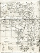 |
| MA0041 | Africa | Africa, 1823. Drawn by J Arrowsmith and engraved by Thomson and Hall and published by A Constable & Co. Engraving with outline hand-colouring. | h 201mm x w 250mm | £25 | 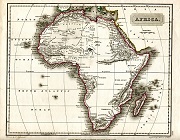 |
| MA0040 | Africa | Africa Minor / Mauritania, c1683. Issued by Cluver.Copper engraving. Condition water staining to bottom edge of map and diagonal crease in top left-hand corner. | h 158mm x w 198mm | £15 | 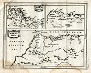 |
| MA0038 | Africa | Northern & Central Africa, c1830. Drawn and engraved by W & D Lizars and published by A Constable. Steel engraving. Condition age discolouration mainly to edges of paper. | h 195mm x w 242mm | £15 | 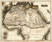 |
| MA0037 | Africa | A Map or Chart of the Cape de Verde Islands Drawn chiefly from that of Capt Roberts which is corrected and improved. Engraved by Thomas Kitchin. Copper engraving. | h 192mm x w 221mm | £60 | 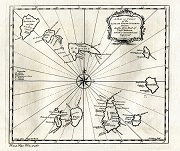 |
| MA0036 | Africa | A Map or Chart of the Cape de Verde Islands Drawn chiefly from that of Capt Roberts which is corrected and improved. Engraved by Thomas Kitchin. Copper engraving withlater hand colouring. | h 192mm x w 221mm | £60 | 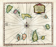 |
| MA0035 | Africa | Africa, c1833. Drawn and engraved by J Dower and published by William Orr. Steel engraving. Condition - central vertical fold as issued. | h 207mm x w 257mm | £15 | 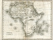 |
| MA0033 | Africa | A Map of the Coast and Country about Sierra Lione and Sherebro River, Map of the River Sierra Lione by Mr Smith, c1753. Published in "The Universal Traveller" by Thomas Salmon Copper engraving | h 215mm xc w 148mm | £38 | 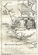 |
| MA0014 | Africa | Insulae Promontorii Viridis Hispanis Issas de Cabo Verde Belgia De Soute Eyanden, 1688. Copper engraving. Condition - central vertical fold as issued. | h 247mm x w 306mm | £250 | 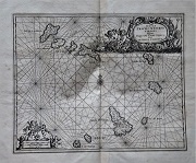 |
| MA0009 | Africa | A New and Accurate Map of Africa, Drawn from the best Authorities by Thomas Bowen, 1777. Engraved for Middleton's Complete System of Geography. Copper engraving. Condition - two vertical folds. | h 337mm x w 405mm | £125 | 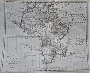 |
| MA0005 | Africa | Ancient Africa or Libya Part II 1 By Philip Smith, RA. Engraved by J & C Walker. Published by the Society for the Diffusion of Useful Knowledge, 1st December 1840. | h 312mm x w 395mm | £20 | 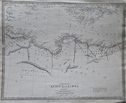 |
| MA0004 | Africa | West Africa I, c1885. Published by Letts, Son & Co Limited. | h 313mm x w 387mm | £30 | 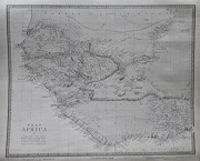 |
| MA0003 | Africa | West Africa II, c1885. Published by Letts, Son & Co Limited. | h 313mm x w 387mm | £30 | 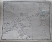 |
| MA0002 | Africa | Ancient Africa or Libya Part 1 By Philip Smith, Univ. Coll. London. Engraved by J & C Walker. Published by the Society for the Diffusion of Useful Knowledge, 18th April 1840. | h 312mm x w 397mm | £20 | 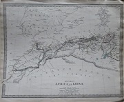 |
| M0198 | Africa | Ortelius, Abraham, c1601. Barbaraia, et Bileldulgerid. This map shows parts of Northern Africa including Morocco, Algeria, Tunisia and Libya. Early hand colouring. | h 82mm x w 120mm | £65 | 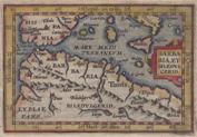 |
| M0152 | Africa | Africa, c1796 . Engraved for Walkers Gazetteer. | h 180mm x w 207mm | £25 | 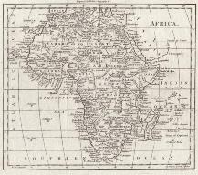 |
| M0150 | Africa | Africa, c1800 . Engraved for Walkers Gazetteer. | h 185mm x w 210mm | £25 |  |
| M0063 | Africa | Robert de Vaugondy, L'Afrique, 1756 with outline colour, Pub France | h18.5in x 23.75in | £80 |  |


